I should think any data collection for Potholes - or the likes - would be more of a proactive framework/driver for state policies, or local council policies, than a solution for drivers?
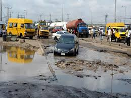
I don’t see how important an app for navigation this would make especially in Lag. Even Other states. Streets roads are not developed, major roads are full of potholes, most just look bad. You don’t see potholes, you just see bad roads.
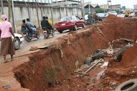
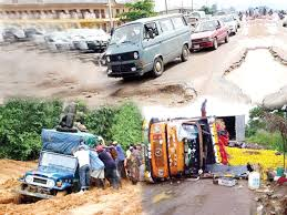
Fresh potholes are ‘dug’ each day, old ones are left to spread, and new roads aren’t built to last. How the heck any system is to keep up with “the pothole developement” on Nigerian roads is really beyond me.
I stand to be enlightened otherwise how important this application would be, if not at its best to provide fresh whip (pun intended) of data for activism platforms like BudgiT to hammer away at state ineptitude.
Una dey discuss this pothole thing like they are just minor glitches on our road, all having the same weight and simply counting them can paint a true picture of the state of the roads.
How can you count a small pothole in Lagos (the size of a pot) as one, and count a medium pothole in Imo state (the size of a mass grave, it’s not big until it looks like an erosion) as one. Not good!
Except you also will collect information on diameter and depth of the grave…sorry pothole.
Long term plan is to give the drivers the opportunity to tag a pothole as fixed when the warning pops up. A score is aggregated from the percentage of truck drivers that do this and the warning is suppressed.
The mechanics you have described sounds pretty good (basically let the road users grade the roads) but for the Nigerian political terrain (excuse the pun) I don’t think it can be executed. Until the political class (government) sees the need to marry IT solutions with their policies we will still be staring at the potholes for a long time.
@princehumphrey I never said it was for the general public. I said it was for a client. It’s an internal solution. Not going to be specific here but think Forte oil and their tankers. It’s not road users grading roads - more like management interested in saving costs on repairs because some driver sped into a surprise ditch.
Yes, our satellites are still in orbit and doing very well. Unfortunately, you need very high Res SATs to map ‘extremely small’ points such as pot-holes. Only USA’s NRO has these kinds of SATs in their possession.
Well bro, here’s to me wishing you luck. No sarcasm. It is a tough one.
On some level its like an application for management absolution against damages. If a driver had the app next time he/she ran into a ditch, ‘repair cost would be coming out of your pocket’.